
- World Radio Map • North America • United States • California • Redding
Radio stations in Redding, CAClick on the radio station name to listen online |
||
| FM,MHz | Station | Transmitter |
| 88.1 |
 KNSQ JPR Rhythm & News KNSQ JPR Rhythm & News
|
Dunsmuir, Mount Bradley |
| 88.5 |
 KKRN Community Radio KKRN Community Radio
|
Hatchet Mountain |
| 88.9 |
 KFPR North State Public Radio KFPR North State Public Radio
|
Shasta Bally |
| 89.3 |
 K207CT CSN Radio K207CT CSN Radio
|
Lakehead |
| 89.7 |
KNCA JPR Rhythm & News
|
Hatchet Mountain |
| 90.1 |
 K211CO Air 1 K211CO Air 1
|
314 Lake Blvd |
| 90.5 |
 KIBC KIBC
|
Hatchet Mountain |
| 90.9 |
 K215BP JPR Classics & News K215BP JPR Classics & News
|
South Fork Mountain |
| 91.3 |
 KNVE Radio Nueva Vida KNVE Radio Nueva Vida
|
South Fork Mountain |
| 91.9 |
 K220IR Effect Radio K220IR Effect Radio
|
Shasta Bally |
| 92.7 |  KYCT The Outlaw KYCT The Outlaw└ HD2  KRAC Talk KRAC Talk
└ HD3  KBLF Best Music KBLF Best Music
|
South Fork Mountain |
| 93.3 |
 K227AE Red 103.1 K227AE Red 103.1
|
South Fork Mountain |
| 93.7 |
 K229CA Bob FM K229CA Bob FM
|
South Fork Mountain |
| 94.3 |
 KRBN Radio Lazer KRBN Radio Lazer
|
Shingletown, Emigrant Trl |
| 94.7 |
 KEWB Power 94 KEWB Power 94
|
South Fork Mountain |
| 95.7 |
 KALF The Wolf KALF The Wolf
|
Red Bluff, Round Mountain |
| 96.1 |
 KYTO True Oldies 96KTO KYTO True Oldies 96KTO
|
Shingletown, Mobile Park Dr |
| 96.5 |
 K243CT Talk Radio K243CT Talk Radio
|
South Fork Mountain |
| 97.3 |
 KNCQ Q97 Country KNCQ Q97 Country
|
Shasta Bally |
| 97.7 |
K249EW Effect Radio
|
South Fork Mountain |
| 98.1 |
 KVIP Christian Radio KVIP Christian Radio
|
South Fork Mountain |
| 98.7 |
K254CN Christian Radio
|
South Fork Mountain |
| 99.3 |
 KWLZ Wild 99.3 KWLZ Wild 99.3
|
South Fork Mountain |
| 99.7 |
 KTOR Radio Mexicana KTOR Radio Mexicana
|
Red Bluff, Tuscan Buttes |
| 100.1 |
 KZRO Z-Channel KZRO Z-Channel
|
Mt. Shasta |
| 100.7 |
 KTHU Thunder 100.7 KTHU Thunder 100.7
|
Red Bluff, Toomes Camp Rd |
| 101.1 |
KWCA JPR Classics & News
|
South Fork Mountain |
| 101.5 |
 K268AJ Family Radio K268AJ Family Radio
|
South Fork Mountain |
| 101.7 |
K269DD Christian Radio
|
Lakehead |
| 101.9 |
 K270AA K-Love K270AA K-Love
|
314 Lake Blvd |
| 102.1 |
 KCEZ Power 102 KCEZ Power 102
|
Red Bluff, Toomes Camp Rd |
| 102.3 |
 KHWA Highway 102.3 KHWA Highway 102.3
|
Mt. Shasta |
| 102.7 |
KKRO Air 1
|
Red Bluff, Inskip Hill |
| 103.1 |
KHRD Red 103.1
|
Shasta Bally |
| 103.9 |
 K280GP Fox Sports Radio K280GP Fox Sports Radio
|
3360 Alta Mesa Dr |
| 104.3 |
 KSHA K-Shasta KSHA K-Shasta
|
South Fork Mountain |
| 104.9 |
 K285FE News Talk K285FE News Talk
|
Shingletown, Dandelion Ln |
| 105.3 |
 KRDG Classic Hits KRDG Classic Hits
|
Shingletown, Dandelion Ln |
| 105.7 |
K289BT News Talk
|
South Fork Mountain |
| 106.1 |
 KRRX Rock 106X KRRX Rock 106X
|
Hatchet Mountain |
| 106.7 |
 KRQR Z-Rock KRQR Z-Rock
|
Red Bluff, Toomes Camp Rd |
| 107.1 |
KESR Bob FM
|
South Fork Mountain |
| 107.5 |
K298AF CSN Radio
|
South Fork Mountain |
| 107.9 |
KKLC K-Love
|
Hatchet Mountain |
| WX,MHz | Station | Transmitter |
| 162.550 |
 WXL88 NOAA Weather Radio WXL88 NOAA Weather Radio
|
South Fork Mountain |
| AM,kHz | Station | Transmitter |
| 540 |
KVIP Christian Radio
|
Bella Vista |
| 570 |
 KCFJ CBS News Radio KCFJ CBS News Radio
|
Alturas |
| 620 |
 KMJC JPR News & Information KMJC JPR News & Information
|
Mt. Shasta |
| 650 |
 KSTE Talk KSTE Talk
|
Sacramento, CA, Eagles Nest Rd |
| 680 |
 KNBR The Sports Leader KNBR The Sports Leader
 Westwood One Sports Westwood One Sports
|
San Francisco, CA, Redwood Shores |
| 710 |
 KFIA The Word KFIA The Word
|
Sacramento, CA, Lincoln, Thunder Valley |
| 780 |
 KKOH News Talk KKOH News Talk
|
Reno, NV, Lemmon Valley |
| 810 |
 KSFO KSFO
|
San Francisco, CA, Newark, Dumbarton Bridge |
| 860 |
 KTRB The Answer KTRB The Answer
|
San Francisco, CA, Hayward, Enterprise Ave |
| 1140 |
 KHTK Sactown Sports
Westwood One Sports KHTK Sactown Sports
Westwood One Sports
|
Sacramento, CA, Blake |
| 1140 |
 KLXR Relevant Radio KLXR Relevant Radio
|
Breslauer |
| 1330 |
KJPR JPR News & Information
|
Shasta Lake |
| 1370 |
KRAC Talk
|
Red Bluff |
| 1400 |
KNRO Fox Sports Radio
|
3360 Alta Mesa Dr |
| 1460 |
KCNR Talk Radio
|
Breslauer |
| 1490 |
KBLF Best Music
|
Red Bluff |
| 1530 |
 KFBK NewsRadio KFBK NewsRadio
|
Sacramento, CA, Pleasant Grove |
| 1610 |
|
I-5 at Hilltop Dr |
| 1670 |
KQMS News Talk
|
3360 Alta Mesa Dr |
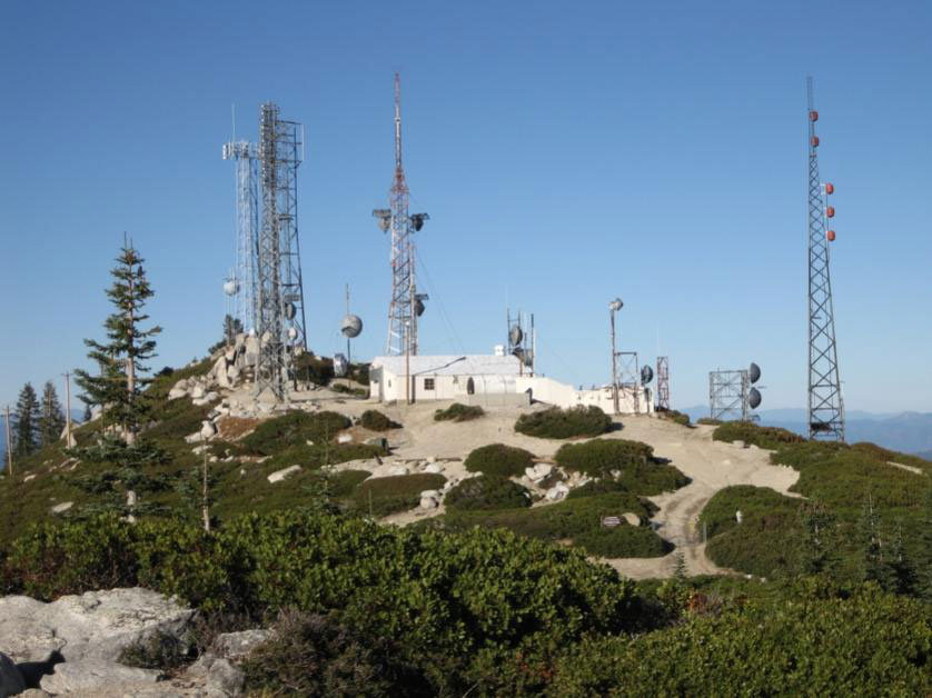
Shasta Bally
Coordinates: 40°36'10" N, 122°39'03" W
Shasta Bally is located 15 miles west of Redding, California, near Whiskeytown reservoir. It is the highest point in Whiskeytown National Recreation Area and is home to many communication towers for local radio and television stations.


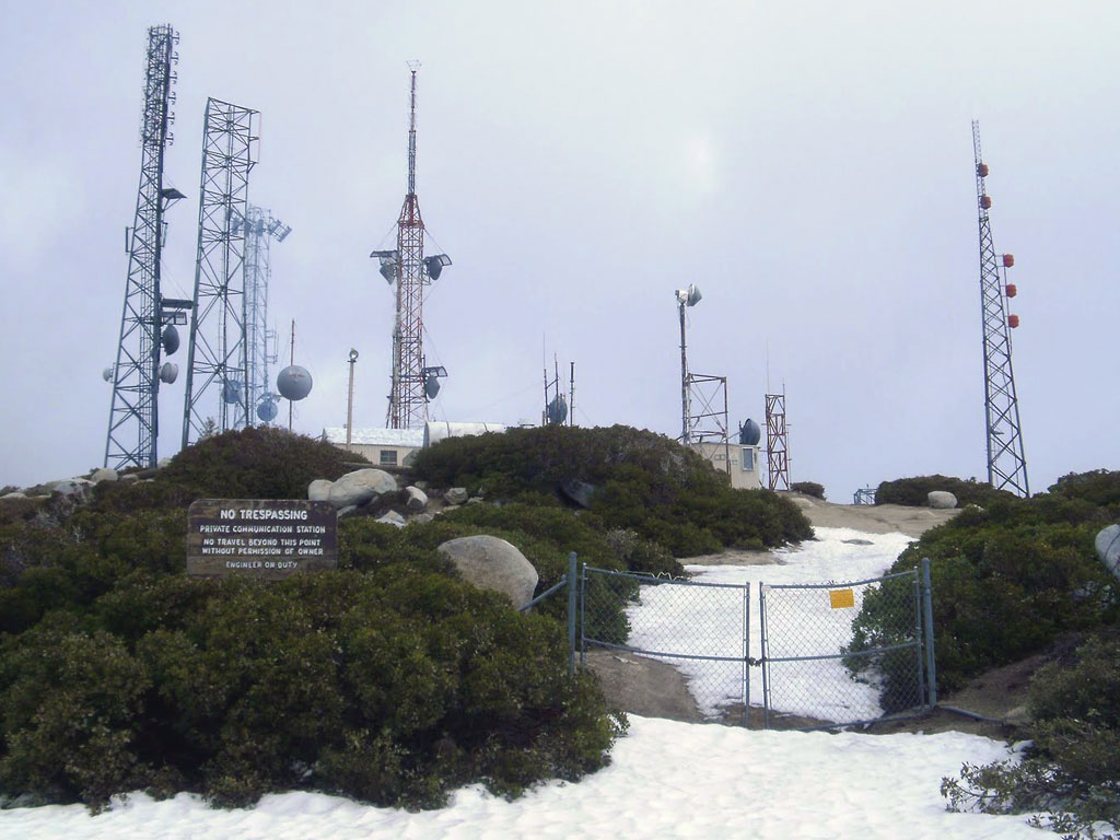
South Fork Mountain
Coordinates: 40°39'15" N, 122°21'19" W
South Fork Mountain is located about 9 miles northwest of Redding, near Iron Mountain Mine.
Useful links
CBA - California Broadcasters Association
California Historical Radio Society
Northern California DX Club
RadioDiscussions.com - California Message Board
Redding, California at Radio-Locator.com
