
- World Radio Map • North America • United States • Massachusetts • Springfield
Radio stations in Springfield, MAClick on the radio station name to listen online |
||
| FM,MHz | Station | Transmitter |
| 88.5 |
 WFCR NEPM News Netw. WFCR NEPM News Netw.
└ HD2  Classical NEPM Classical NEPM
└ SCA  Valley Eye Radio Valley Eye Radio
|
Amherst, Mount Lincoln |
| 88.9 |
 WJMJ Catholic Radio WJMJ Catholic Radio
 EWTN Catholic Radio EWTN Catholic Radio
|
Hartford, CT, Rattlesnake Mountain |
| 89.3 |
 WAMH WAMH
|
Amherst, Mount Lincoln |
| 89.5 |
 WSKB WSKB
|
Westfield, Westfield State University |
| 89.5 |
 WWQZ The Life FM WWQZ The Life FM
|
Hampden |
| 89.9 |
 WSCB WSCB
|
Springfield College |
| 90.3 |
 WAMC Northeast Public Radio WAMC Northeast Public Radio
└ HD2 WAMC HD2
|
Albany, NY, Mount Greylock, MA |
| 90.7 |
 WTCC WTCC
|
Springfield Technical Community College |
| 91.3 |
 WWUH WWUH
|
Hartford, CT, Avon Mountain, 275 Deercliff Rd |
| 91.9 |
WAIC Classical NEPM
|
American International College |
| 92.5 |
 WWYZ Country 92.5 WWYZ Country 92.5
|
Hartford, CT, Meriden, West Peak |
| 93.1 |
 WHYN Mix 93.1 WHYN Mix 93.1
└ HD2  The Beat The Beat
|
Hoyoke, Mount Tom |
| 93.7 |
 WZMX Hot 93.7 WZMX Hot 93.7
└ HD2  Channel Q Channel Q
└ HD3  Roadblock Radio Roadblock Radio
|
Hartford, CT, Meriden, West Peak |
| 93.9 |
 WRSI The River WRSI The River
|
Greenfield, Horse Mountain |
| 94.3 |
 W232BW Rewind 94.3 W232BW Rewind 94.3
|
Amherst, Mount Lincoln |
| 94.7 |
 WMAS WMAS
└ HD2  La Nueva 98.1 La Nueva 98.1
|
101 West St |
| 95.7 |
 WKSS Kiss FM WKSS Kiss FM
└ HD2  Pride Radio Pride Radio
|
Hartford, CT, Meriden, West Peak |
| 96.1 |
 WSRS 96-1 SRS WSRS 96-1 SRS
└ HD2  WTAG NewsRadio WTAG NewsRadio
|
Worcester, MA, Paxton, Asnebumskit Hill |
| 96.5 |
 WTIC TIC-FM WTIC TIC-FM
└ HD2  WTIC News Talk WTIC News Talk
|
Hartford, CT, Avon Mountain, 275 Deercliff Rd |
| 96.9 |
 W245BK Pure Oldies W245BK Pure Oldies
|
Northampton, Horse Mountain |
| 97.1 |
 W246CC Bomba Radio W246CC Bomba Radio
|
Hartford, CT, Vernon Falls Park |
| 97.3 |
W247DL The Beat
|
Feeding Hills, Provin Mountain |
| 97.7 |
 W249DP Classic Hits W249DP Classic Hits
|
Palmer |
| 97.9 |
 WUCS Fox Sports WUCS Fox Sports
└ HD2  Magic Magic
|
Hartford, CT, 185 Asylum St, City Place I |
| 98.1 |
W251CT La Nueva 98.1
|
101 West St |
| 98.3 |
 WHAI Valley's Best Variety WHAI Valley's Best Variety
|
Greenfield |
| 98.5 |
 W253CD Lazer 99.3/98.5 W253CD Lazer 99.3/98.5
|
East Longmeadow, 45 Fisher Ave |
| 99.3 |
WLZX Lazer 99.3/98.5
└ HD2 Rewind 94.3
└ HD3 Pure Oldies
|
Northampton, Horse Mountain |
| 99.7 |
 WLCQ The Q WLCQ The Q
|
Feeding Hills, 522 Springfield St |
| 100.1 |
 W261DD Jammin 100.1 W261DD Jammin 100.1
|
West Springfield, River St |
| 100.5 |
 WRCH Lite 100.5 WRCH Lite 100.5
└ HD2  Smooth Jazz Netw. Smooth Jazz Netw.
└ HD3  WEEI Sports Radio WEEI Sports Radio
|
Hartford, CT, Farmington, Rattlesnake Mountain |
| 100.9 |
 WRNX Kix 100.9 WRNX Kix 100.9
|
Hoyoke, Mount Tom |
| 101.3 |
 WKCI KC101 WKCI KC101
└ HD2  The Beat The Beat
|
New Haven, CT, Gaylord Mountain Rd |
| 101.5 |
 W268CZ News Talk W268CZ News Talk
|
Northampton, Horse Mountain |
| 102.1 |
 WAQY Rock 102 WAQY Rock 102
└ HD2 Lazer 99.3/98.5
|
Feeding Hills, Provin Mountain |
| 102.5 |
 WZCS Católica Springfield WZCS Católica Springfield
|
Chicopee, 481 Center St |
| 102.9 |
 WDRC The Whale WDRC The Whale
└ HD2  Big D 103 Big D 103
└ HD3  Talk of Connecticut Talk of Connecticut
|
Hartford, CT, Meriden, West Peak |
| 103.3 |
 WXOJ Valley Free Radio WXOJ Valley Free Radio
|
Northampton, 448 Florence Rd |
| 103.5 |
 WCCH WCCH
|
Holyoke, Holyoke Community College |
| 104.1 |
 WMRQ Radio 104.1 WMRQ Radio 104.1
└ HD2 Bomba Radio
└ HD3  Radio Familia Radio Familia
└ HD4 Bomba Radio
|
Hartford, CT, Meriden, West Peak |
| 104.5 |
W230BH Bomba Radio
|
Chicopee, 481 Center St |
| 104.9 |
 WREA Radio Redentor WREA Radio Redentor
|
Holyoke, Evergreen Dr |
| 105.1 |
W249CD Lazer 99.3
|
East Longmeadow, 45 Fisher Ave |
| 105.5 |
 WWEI Sports Radio WEEI WWEI Sports Radio WEEI
|
Hoyoke, Mount Tom |
| 105.9 |
 WHCN The River WHCN The River
|
Hartford, CT, Meriden, West Peak |
| 106.3 |
 WEIB Smooth FM WEIB Smooth FM
|
Northampton, Horse Mountain |
| 106.9 |
 WCCC K-Love WCCC K-Love
|
Hartford, CT, Avon Mountain, 3114 Albany Ave |
| 107.7 |
 WACC Asnuntuck Radio WACC Asnuntuck Radio
|
Enfield, CT |
| 107.9 |
 WLHZ La Hora Zero WLHZ La Hora Zero
|
Westfield, Susan Dr |
| WX,MHz | Station | Transmitter |
| 162.400 |
 WXJ42 NOAA Weather Radio WXJ42 NOAA Weather Radio
|
Meriden, CT, West Peak |
| 162.475 |
WXJ41 NOAA Weather Radio
|
Somers, CT, Soapstone Mountain |
| 162.550 |
WXL93 NOAA Weather Radio
|
Worcester, MA, Paxton, Asnebumskit Hill |
| AM,kHz | Station | Transmitter |
| 560 |
WHYN NewsRadio
|
Holyoke |
| 580 |
WTAG NewsRadio
|
Worcester, MA, Holden |
| 640 |
WNNZ NEPM News Netw.
|
Westfield |
| 660 |
 WFAN Sports Radio WFAN Sports Radio
|
New York, NY, The Bronx, High Island |
| 680 |
 WRKO The Voice of Boston WRKO The Voice of Boston
|
Boston, MA, Burlington, Meadow Rd |
| 700 |
 WQVD Classic Hits WQVD Classic Hits
|
Orange-Athol |
| 710 |
 WOR The Voice of New York WOR The Voice of New York
|
New York, NY, Lyndhurst, NJ |
| 730 |
 WACE The Station of the Cross
EWTN Catholic Radio WACE The Station of the Cross
EWTN Catholic Radio
|
Chicopee, 326 Chicopee St |
| 760 |
 WVNE Life Changing Radio WVNE Life Changing Radio
|
Worcester, MA, North Brookfield |
| 770 |
 WABC WABC
|
New York, NY, Lodi, NJ |
| 810 |
 WGY News Talk WGY News Talk
|
Albany, NY, Rotterdam, I-90 exit 25A |
| 830 |
 WCRN News Talk WCRN News Talk
|
Worcester, MA, Leicester |
| 850 |
 WEEI WEEI
|
Boston, MA, Needham, 1555 Central Ave |
| 880 |
 WHSQ ESPN New York 880 WHSQ ESPN New York 880
|
New York, NY, The Bronx, High Island |
| 910 |
 WLAT Relevant Radio WLAT Relevant Radio
|
Hartford, CT, Farmington, Rattlesnake Mountain |
| 940 |
WQVR Classic Hits
|
Webster |
| 970 |
WESO The Station of the Cross
EWTN Catholic Radio
|
Southbridge |
| 990 |
 WNTY Kool Radio WNTY Kool Radio
|
Hartford, CT, Southington |
| 1030 |
 WBZ Newsradio WBZ Newsradio
|
Boston, MA, Hull, Newport Rd |
| 1080 |
WTIC News Talk
|
Hartford, CT, Avon Mountain, 375 Deercliff Rd |
| 1130 |
 WBBR Bloomberg Radio WBBR Bloomberg Radio
|
New York, NY, Carlstadt, NJ |
| 1200 |
 WXKS Talk 1200 WXKS Talk 1200
|
Boston, MA, Newton, 750 Saw Mill Brook Pkwy |
| 1250 |
WARE Classic Hits
|
Ware |
| 1270 |
WACM Jammin 100.1
|
West Springfield, 138 Palmer Ave |
| 1320 |
 WATR WOW Radio WATR WOW Radio
|
Waterbury, CT, 79 Baldwin Ave |
| 1360 |
WDRC Talk of Connecticut
|
Hartford, CT, Blue Hills |
| 1400 |
WHMP News Talk
|
Northampton |
| 1410 |
WPOP NewsRadio
|
Hartford, CT, New Britain, Central Connecticut State University |
| 1440 |
 WVEI Sports Radio WEEI WVEI Sports Radio WEEI
|
Worcester, MA, 181 Moreland St |
| 1450 |
WHLL La Nueva 98.1
|
101 West St |
| 1490 |
WSPR Bomba Radio
|
West Springfield, River St |
| 1520 |
WIZZ Pure Oldies
|
Greenfield |
| 1550 |
WSDK Life Changing Radio
|
Hartford, CT, Bloomfield |
| 1600 |
WLZX Lazer 99.3/98.5
|
East Longmeadow, 45 Fisher Ave |
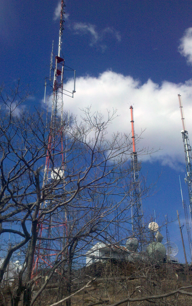
Hoyoke, Mount Tom
Coordinates: 42°14'30" N, 72°38'53" W
Mount Tom is a steep, rugged traprock mountain peak on the west bank of the Connecticut River 10 miles north of downtown Springfield, overlooking Holyoke, Massachusetts. The mountain is the southernmost and highest peak of the Mount Tom Range. Mount Tom is the transmitter location for three Springfield–Holyoke television stations: WGBY-TV (PBS Ch. 57), WGGB-TV (ABC/Fox Ch. 40), and WSHM-LD (CBS Ch. 3), and for radio stations WHYN-FM and WVEI-FM.

Useful links
MBA - Massachusetts Broadcasters Association
NECRAT - Pioneer Valley, Massachusetts radio stations
NEAR-Fest - The New England Amateur Radio Festival
Fybush.com - NorthEast Radio Watch
Tophour.com audio: Springfield Legal IDs
RadioDiscussions.com - Massachusetts Message Board
Springfield, Massachusetts at Radio-Locator.com
