
- World Radio Map • North America • United States • Maine • Augusta
Radio stations in Augusta, MEClick on the radio station name to listen online |
||
| FM,MHz | Station | Transmitter |
| 88.1 |
 WMEY Reach FM WMEY Reach FM
|
Bowdoin |
| 88.9 |
 WMDR God's Country WMDR God's Country
|
South Paris, Streaked Mountain |
| 89.3 |
 WMSJ K-Love WMSJ K-Love
|
Portland, ME, Falmouth, Blackstrap Rd |
| 89.5 |
 WWTP Relevant Radio WWTP Relevant Radio
|
Rte 202 at Ingraham Mountain Rd |
| 89.9 |
 WERU Community Radio WERU Community Radio
|
Blue Hill Mountain |
| 90.1 |
 WMEA Maine Public Radio WMEA Maine Public Radio
└ HD2 Maine Public Classical
|
Portland, ME, Sebago, Douglas Mountain |
| 90.5 |
WMEP Maine Public Radio
└ HD2 Maine Public Classical
|
Camden, Ragged Mountain |
| 91.3 |
WMEW Maine Public Radio
└ HD2 Maine Public Classical
|
Waterville, Cook Hill |
| 91.9 |
 WYFP Bible Broadcasting Netw. WYFP Bible Broadcasting Netw.
|
Portland, ME, Harpswell, Bailey Island |
| 92.3 |
 WMME 92 Moose WMME 92 Moose
|
Rte 202 at Bolton Hill Rd |
| 93.1 |
 WMGX Coast 93.1 WMGX Coast 93.1
└ HD2  WGAN NewsRadio WGAN NewsRadio
└ HD3 Bible Broadcasting Netw.
|
Portland, ME, Presumpscot St |
| 93.5 |
 WCTB True Country WCTB True Country
|
Skowhegan, 195 Middle Rd |
| 93.9 |
 WARX Air 1 WARX Air 1
|
Litchfield, Oak Hill |
| 94.3 |
 W232CU The Arrow W232CU The Arrow
|
160 Bangor St |
| 94.9 |
 WHOM WHOM
|
Mount Washington, NH |
| 95.3 |
WWWA Reach FM
|
Skowhegan, Bigelow Hill |
| 95.5 |
 WPPI Sports Radio WEEI WPPI Sports Radio WEEI
 ESPN Radio ESPN Radio
|
Brunswick, Old Portland Rd |
| 96.3 |
 WJJB The Big JAB WJJB The Big JAB
|
South Paris, Streaked Mountain |
| 96.7 |
WBQA Maine Public Classical
|
Newcastle |
| 97.1 |
 WBFB The Bear WBFB The Bear
|
Bangor, ME, Dixmont, Peaked Mountain |
| 97.5 |
 WQSK Kiss FM WQSK Kiss FM
|
Madison |
| 97.9 |
 WJBQ Q97.9 WJBQ Q97.9
|
Portland, ME, South Gray American Tower |
| 98.5 |
 WEBB B-98.5 WEBB B-98.5
|
Waterville, Benton Ave |
| 98.9 |
 WCLZ Different is Good WCLZ Different is Good
|
Brunswick, I-295 at River Rd |
| 99.3 |
 WKTJ Big Hits WKTJ Big Hits
|
Farmington |
| 99.5 |
 WJCX Life Begins at the Cross WJCX Life Begins at the Cross
|
Bangor, ME, Pittsfield |
| 99.7 |
W259BY Maine Public Classical
|
Waterville, Cook Hill |
| 99.9 |
 WTHT The Wolf WTHT The Wolf
|
Portland, ME, Lewiston, New Gloucester |
| 100.3 |
 WKIT Rock 'n' Roll WKIT Rock 'n' Roll
|
Bangor, ME, South Brewer, Kings Mountain |
| 100.5 |
W265CO K-Love
|
Rte 202 at Bolton Hill Rd |
| 101.3 |
 WVQM The Voice Of Maine WVQM The Voice Of Maine
|
Hallowell, Winthrop St |
| 101.7 |
WSVV K-Love
|
Bangor, ME, Frankfort, Mount Waldo |
| 101.9 |
 WPOR Today's Country WPOR Today's Country
|
Portland, ME, Falmouth, Blackstrap Rd |
| 102.1 |
WZVV K-Love
|
Bangor, ME, Dexter Mountain, Hersey Hill |
| 102.5 |
WQSS Kiss FM
|
Camden, Ragged Mountain |
| 102.9 |
 WBLM Rock Station WBLM Rock Station
|
Portland, ME, Raymond |
| 103.3 |
WMCM The Bear
|
Rockland, Benner Hill |
| 103.7 |
 WPKQ WCYY Rock WPKQ WCYY Rock
|
Mount Washington, NH |
| 103.9 |
WVOM The Voice Of Maine
|
Bangor, ME, Passadumkeag Mountain |
| 104.3 |
 WABK Big 104 WABK Big 104
|
Hallowell, Winthrop St |
| 104.7 |
WBAK Big 104
|
Bangor, ME, Frankfort, Mount Waldo |
| 105.1 |
 WTOS Pure Rock WTOS Pure Rock
|
Skowhegan, Sugarloaf Mountain |
| 105.5 |
 WBYA The Wave WBYA The Wave
|
Belfast, Northport |
| 105.9 |
 WBCI Life Changing Radio WBCI Life Changing Radio
|
Bowdoin |
| 106.5 |
 WQCB Q 106.5 WQCB Q 106.5
|
Bangor, ME, Dexter Mountain, Mansfield Ledge |
| 106.9 |
 WBQX Frank FM WBQX Frank FM
|
Rockland, Thomaston |
| 107.3 |
 WBZN Z107.3 WBZN Z107.3
|
Bangor, ME, Alton, Tannery Rd |
| 107.5 |
WFNK Frank FM
|
Auburn, Poland Springs |
| 107.9 |
 WFMX Mix 107.9 WFMX Mix 107.9
|
Oakland, S Gage Rd |
| WX,MHz | Station | Transmitter |
| 162.450 |
 WNG547 NOAA Weather Radio WNG547 NOAA Weather Radio
|
Skowhegan, Sugarloaf Mountain |
| 162.475 |
WSM60 NOAA Weather Radio
|
Dresden, Blinn Hill |
| 162.500 |
KZZ41 NOAA Weather Radio
|
Mount Washington, NH |
| AM,kHz | Station | Transmitter |
| 560 |
WGAN NewsRadio
|
Portland, ME, 236 Lane Ave |
| 590 |
 WEZE The Word WEZE The Word
|
Boston, MA, Medford, Commercial St |
| 680 |
 WRKO The Voice of Boston WRKO The Voice of Boston
|
Boston, MA, Burlington, Meadow Rd |
| 690 |
 CKGM TSN Radio 690
ESPN Radio CKGM TSN Radio 690
ESPN Radio
|
Canada, Montreal, QC, Mercier |
| 750 |
 WJTO Memories Channel WJTO Memories Channel
|
Bath, Austin Rd |
| 850 |
 WEEI WEEI
|
Boston, MA, Needham, 1555 Central Ave |
| 900 |
 WCME News Station WCME News Station
|
Brunswick, Old Portland Rd |
| 930 |
 CFBC Country Favourites CFBC Country Favourites
|
Canada, Saint John, NB, Sheldon Point Trl |
| 940 |
 CFNV CFNV
|
Canada, Montreal, QC, Mercier |
| 970 |
 WZAN The Outlaw WZAN The Outlaw
|
Portland, ME, Scarborough, Elmwood Ave |
| 1030 |
 WBZ Newsradio WBZ Newsradio
|
Boston, MA, Hull, Newport Rd |
| 1160 |
 WSKW The Score WSKW The Score
 Westwood One Sports Westwood One Sports
|
Skowhegan, 195 Middle Rd |
| 1240 |
 WIGY Radio WIGY Radio
|
Auburn |
| 1280 |
 WJYE Hot Radio Maine WJYE Hot Radio Maine
|
Gardiner |
| 1340 |
WMDR The Arrow
|
160 Bangor St |
| 1470 |
WLAM Memories Channel
|
Auburn, Washington St N |
| 1510 |
 WMEX The Greatest Hits WMEX The Greatest Hits
|
Boston, MA, Quincy, Harriet St |
| 1610 |
 WPVS949 Hwy Advisory Radio WPVS949 Hwy Advisory Radio
|
Maine Turnpike (I-95) |
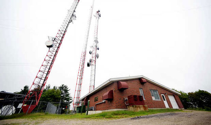
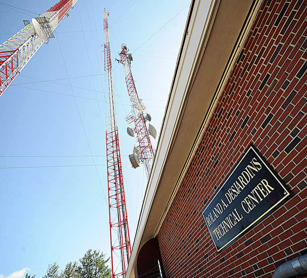
Litchfield, Danforth Hill and Oak Hill
Coordinates: 44°09'15" N, 70°00'35" W
Danforth Hill in Litchfield, Maine, southwest of Augusta and northeast of Lewiston is home to three transmitter towers for Central Maine:
• 634 ft (193.2 m) tall Maine Public Broadcasting Corporation - WCBB-TV (PBS Ch. 10) tower,
• 720 ft (219.5 m) tall Sinclair Broadcast Group - WPFO-TV (Fox Ch. 23) tower and
• 303 ft (92.5 m) tall Educational Media Foundation - WARX-FM (Air1 93.9 MHz) tower on nearby Oak Hill.

Useful links
MAB - Maine Association of Broadcasters
NECRAT - Augusta, Maine radio stations
NEAR-Fest - The New England Amateur Radio Festival
Fybush.com - NorthEast Radio Watch
Fybush.com Tower site of the week: Danforth Hill, Litchfield, Maine (2003)
Tophour.com audio: Augusta Legal IDs
RadioDiscussions.com - Northern New England Message Board
RadioDiscussions.com - Maine Message Board
Augusta, Maine at Radio-Locator.com
